

Overview
- Data collection and analysis
- Developing and evaluating alternatives
- Developing a highway improvement plan

Public Involvement
View Public Meeting #1 Resources from November 15, 2022
- View the public meeting recording.
- View the presentation slides.
- View the public meeting summary.
- View the public comments and responses.
View Public Meeting #2 Resources from April 25, 2023
- View the public meeting recording.
- View the presentation slides.
- View the public meeting summary.
- View the public comments and responses.
View Public Meeting #3 Resources from February 27, 2024
- View the public meeting recording.
- View the presentation slides.
Needs

I-40 Corridor Needs Include:
- Improving Traffic Operations and Reliability – Traffic back-ups on I-40 are caused by construction, maintenance, and incidents. Reducing I-40 to 1-lane for any reason during daytime areas is problematic. Solutions are needed to reduce lane closures, improve incident management, and improve traveler information systems.
- Improving Safety – Safety improvements are needed. I-40 has interchange access ramps that needed to be extended and curves that need corrections. Crashes have been increasing and fatal and serious injury crash rates are higher than state averages.
- Improving Roadway and Infrastructure Condition – Pavement needs to be improved, several bridges need repair or replacement, and many drainage structures need to be expanded or repaired.
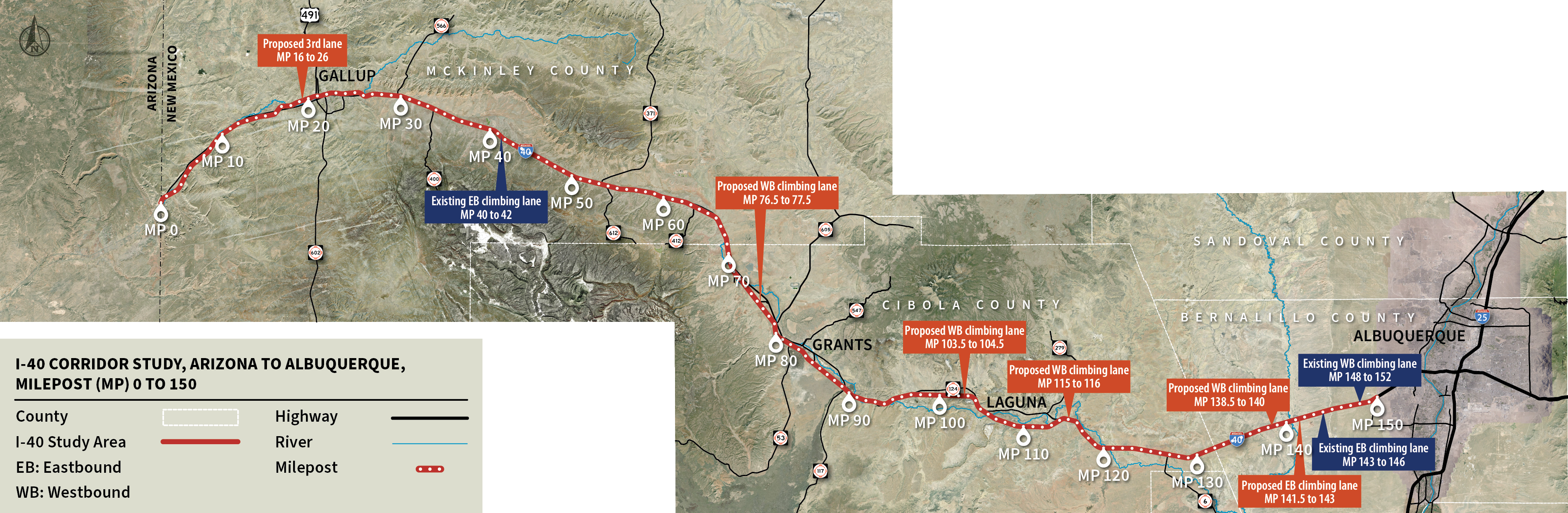
- Roadway Capacity and Growth – The long-term plan must be able to adapt to changes in technology and growth. I-40 with 2-travel lanes in each direction is expected to be sufficient in most areas through 2050. However, ongoing traffic monitoring will be needed, and a third lane will be needed before 2050 in Gallup and on isolated uphill grades.
Alternatives
The study team considered several initial alternatives including 7 concepts to improve I-40 and 7 operational enhancements. These 14 initial concepts were screened to 2 proposed build alternatives and 4 operational enhancements as listed below.
Build Alternatives
- Build Alternative 1: Enhanced 2-Lane with Added Lanes (Recommended)
- Build Alternative 2: 3-Lane Alternative
Operational Enhancements
- Minimize Lane Closures during Construction and Maintenance
- Improve Intelligent Transportation Systems (ITS)
- Improve Alternate Routes
- Improve Incident Management
This video shows the existing I-40 roadway and the proposed Enhanced 2-Lane with Added Lanes and 3-Lane alternatives. The graphic below shows the existing I-40 roadway.
Custom CSS: display:none;
Your content goes here. Edit or remove this text inline or in the module Content settings. You can also style every aspect of this content in the module Design settings and even apply custom CSS to this text in the module Advanced settings.
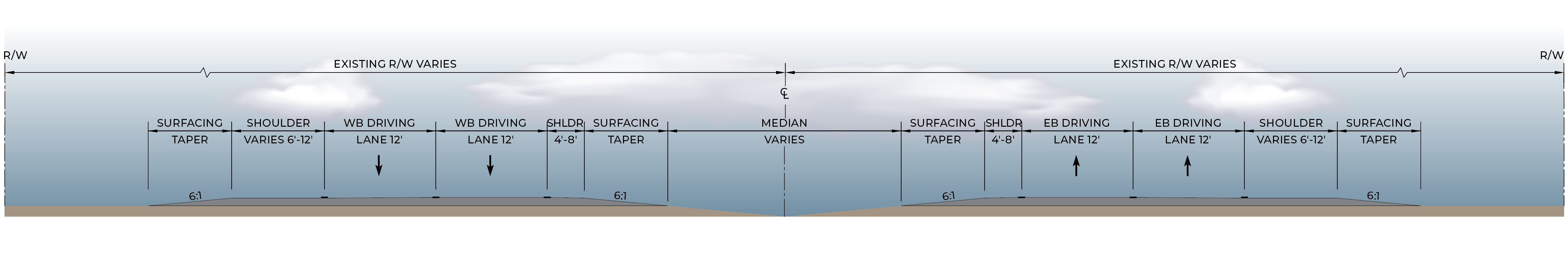
Build Alternative 1: Enhanced 2-Lane with Added Lanes (Recommended)
The Enhanced 2-Lane with Added Lanes Alternative would continue to provide 2 lanes in each direction of I-40, as shown in the typical section below:
In addition:
- Inside and outside shoulders would be widened to 12 feet. This would provide space to improve incident management as shown in this video and would allow for 2-lanes to be maintained during construction and maintenance as shown in this video.
- Curve, pavement, bridge, and drainage needs would be addressed.
- Interchange access ramps would be improved to meet current design guidelines as shown in this video.
- A third lane would be provided where needed, including Gallup and on steep grades as shown in the graphic below:
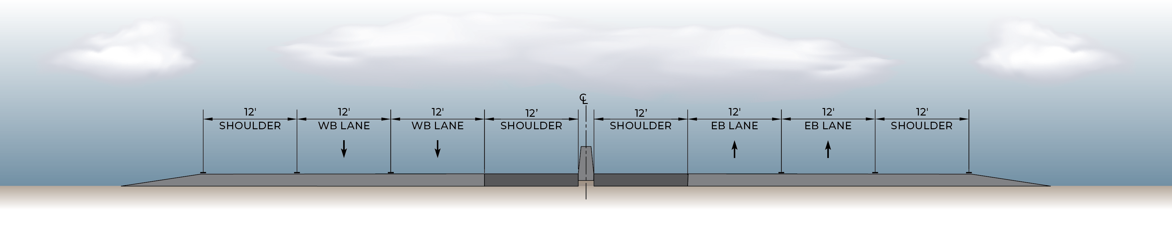
Build Alternative 2: 3-Lane Alternative
This alternative would include all of the elements of the Enhanced 2-Lane with Added Lanes Alternative plus a third travel lane would be provided in each direction for the full 150-mile corridor. The graphic below shows an example of a typical section of the 3-Lane Alternative:
Estimated Costs
| Alternative | Average Cost Per Mile | Total |
| Enhanced 2-Lane with Added Lanes (includes 13 miles of 3-Lane roadway) |
$24 to 26 million | $3.6 to 3.9 billion |
| 3-Lane | $30 to 32 million | $4.5 to 4.8 billion |
- Cost estimates are preliminary and are for comparison and discussion purposes only. Estimates are in 2023 dollars and do not include project development, right-of-way, or New Mexico Gross Receipts Tax.
- Costs do not include operational enhancements which are discussed in the Operational Enhancements section.
Alternatives Evaluation and Recommendation
The build alternatives were evaluated using the criteria listed below:
- Traffic Operations and Future Traffic Growth – Both alternatives are expected to accommodate expected future traffic growth between now and 2050.
- Safety – Both alternatives improve safety by lengthening interchange ramps, correcting curves, and widening shoulders.
- Maintenance of Traffic during Construction – Both alternatives can be built while maintaining 2 lanes on I-40.
- Maintenance of Traffic during Incidents, Maintenance, and Construction Once Built – The Enhanced 2-Lane is a substantial improvement over existing conditions, but the 3-Lane Alternative provides more space and flexibility.
- Right-of-Way Impacts – Impacts are not expected for either alternative, based on conceptual design.
- Environmental Considerations – The 3-Lane Alternative has a larger footprint and more potential effects to cultural and natural resources, but differences are minor.
- Cost – Construction costs for the 3-Lane Alternative are about 25% to 30% more than the Enhanced 2-Lane with Added Lanes Alternative because it is about 24 feet wider. The 3-Lane Alternative will also have higher maintenance costs.
Recommendation
The Enhanced 2-Lane with Added Lanes Alternative is recommended because it:
- Improves traffic operations and reliability by reducing the main causes of traffic back-ups – construction, maintenance, and incidents.
- Responds to safety and infrastructure needs by addressing pavement condition, interchange ramps that need to be improved, and curves that need to be corrected to meet current roadway design guidelines.
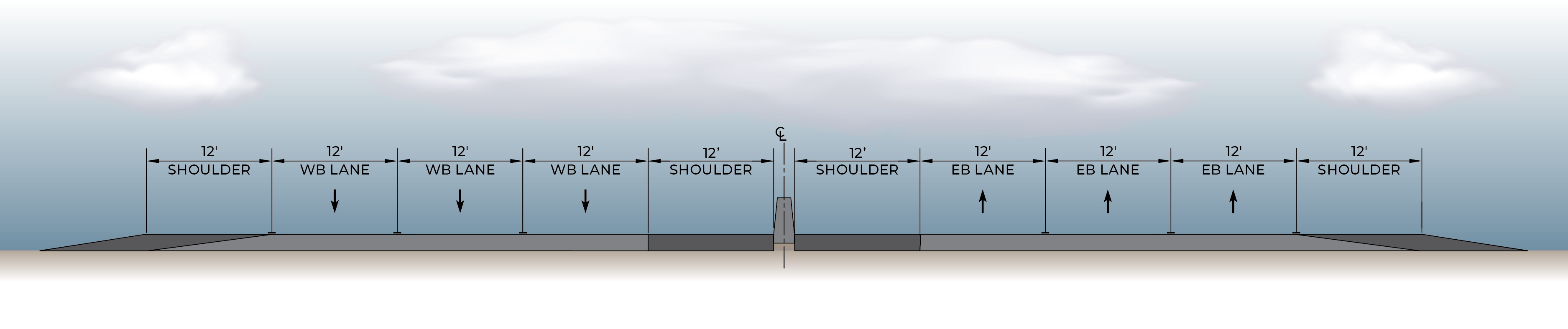
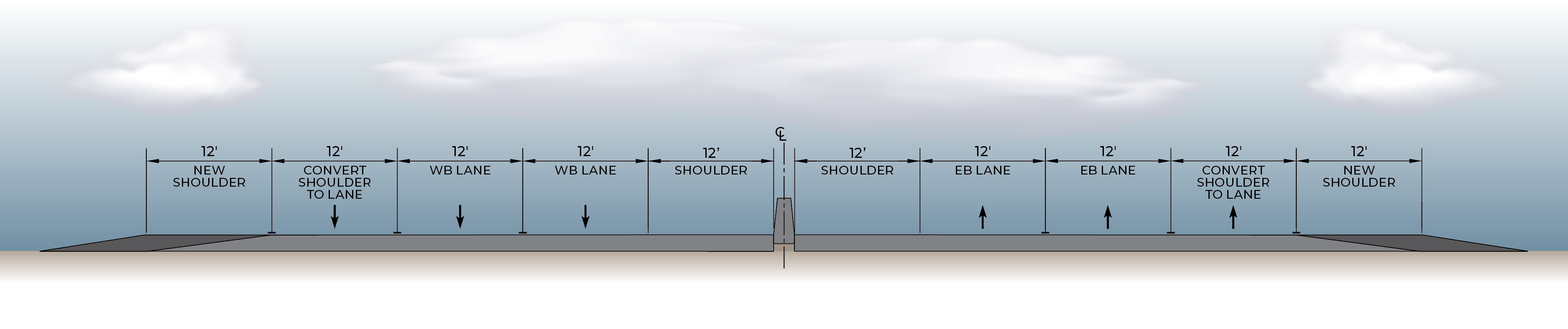
- Meets expected future traffic growth and is “future ready” for easy expansion to 3-lanes by converting one of the shoulders to a lane and adding a new shoulder as shown in the graphic below:
Operational Enhancements
Both build alternatives would incorporate the following operational enhancements to improve safety and operations on I-40:
Minimize Lane Closures During Construction and Maintenance
This includes developing and implementing approaches to minimize disruptions to traffic during construction and maintenance activities such as:
- Maintaining 2 travel lanes on I-40 in each direction during construction.
- Developing and implementing policies to maintain 2 travel lanes on I-40 as much as possible during daytime hours. This may include doing maintenance during nighttime or off-peak hours when 2 travel lanes cannot be maintained.
Estimated Costs
Costs to maintain 2 lanes during construction are included in estimated construction costs for both build alternatives. Costs to conduct maintenance during off-peak hours will depend on the type of maintenance, time of day, and location and will be determined on a case-by case basis.
____
Improve Intelligent Transportation System (ITS)
ITS technologies augment traditional roadway infrastructure by integrating advanced communications technologies to improve transportation operations, efficiency, and reliability. Proposed ITS improvements for I-40 include:
- Data Collection Stations – Upgrade existing data collection systems on I-40 and add up to 10 additional stations.
- Cameras, Messaging Signs, and Weather Information Systems – NMDOT currently has 9 cameras, 5 messaging signs, and 2 weather information systems that provide real-time information to drivers on I-40. Existing messaging signs would be replaced and additional cameras are proposed.
- Fiber Optic Communications Network – Expanding the existing 25-mile fiber optic network to the entire 150-mile corridor is proposed to connect ITS devices and improve information provided to travelers.
- District 6 Traffic Management Center – Development of a Traffic Management Center in District 6 is proposed to enable remote ITS operations and management and to coordinate with key stakeholders such as police, state patrol, and emergency services.
- Truck Parking Availability System – This system would provide information on available truck parking in the study area.
Estimated Costs
Costs for proposed ITS improvements are estimated at about $30 million in 2023 dollars and do not include project development, right-of-way or New Mexico Gross Receipts Tax. In addition, estimated costs do not include labor or annual operations costs for the District 6 Traffic Management Center.
____
Improve Alternate Routes
This includes improving existing frontage roads adjacent to I-40 to provide alternate routes by:
- Repairing or replacing bridges and pavement on existing routes, where needed.
- Removing vertical clearance constraints for trucks on existing alternate routes. Specifically, this includes replacing the concrete box culverts located near milepost 8.4 on NM 118 west of Gallup and milepost 90.6 on NM 124 east of Grants.
Estimated Costs
Costs for improving alternate routes will be determined on a case-by-case basis for bridge improvements and removing vertical clearance constraints. Estimated costs for reconstructing or rehabilitating pavement on alternate routes are provided below:
- Costs for reconstructing pavement on a 2-lane roadway with 2-foot shoulders is estimated at $2.1 million per mile and rehabilitation costs are estimated at $750,000 per mile.
- Costs for reconstructing pavement on wider roadways (such as Route 66 in Gallup that has 4 lanes, a center turn lane, and 8-foot shoulders) are estimated at $4 million per mile and rehabilitation costs are estimated at $1.7 million per mile.
- Costs do not include project development or New Mexico Gross Receipts Tax.
____
Improve Incident Management
Widening roadway shoulders on I-40 will improve the ability of emergency responders to respond to incidents and get traffic moving. NMDOT will continue to work with the legislature and law enforcement to improve incident management through improved coordination and training and supporting incident response.
Estimated Costs
Costs for improved incident management would depend on the policies and procedures developed and would be determined on a case-by-case basis.
Simulations

This video shows the existing I-40 roadway and the proposed Enhanced 2-Lane with Added Lanes and 3-Lane Alternatives.

This video shows an example of a ramp improvement.

This video shows how wider shoulders could be used for incident management to get 1 or 2 lanes moving as soon as possible.

This video shows how wider roadway shoulders allows for 2 lanes to be provided on I-40 during construction and maintenance.
Timeline

Spring/Fall 2022
- Collect and analyze data
- Virtual public meeting #1, November 15, 2022

Winter/Spring 2023
- Establish needs for improvements
- Identify and screen alternatives
- Virtual public meeting #2, April 25, 2023

Spring/Summer 2023
- Refine and evaluate selected alternatives

Fall/Winter 2023
- Identify recommended alternative(s)
- Develop the Draft I-40 Corridor Study

2024
- Virtual Public Meeting #3 February 27, 2024
- Finalize the I-40 Corridor Study
Counties
McKinley
Cibola
Bernalillo
Districts
3 and 6
STIP Number
Status
Study and Design
Contact
[email protected]
Stephanie Miller
505-445-5464